

Fazenda Macaco

Area Location


FIRM NASA
NASA's Fire Information for Resource Management System (FIRMS) provides near-real-time data on active fires using satellite observations.

(CMR) was developed to enable daily monitoring of occurrences such as deforestation, degradation, changes in land use and occupation in these territories.
Indigenous Area
Greenline does not allow the use of land areas that overlap any indigenous lands, therefore through the FUNAI Monitoring Portal, it is demonstrated and proven here that the land areas do not overlap indigenous lands .

Pigmentation Analysis and Carbon Sequestration
2023 - 2024
2023


2023


2023


2023


2023


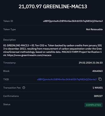
Year 2013 (January to December)
TOKEN ID: u8BYQpmtwXv2t894mfax3kXr6X5h7ajN81kQZ4sntoJ
Name: GREENLINE-MAC13
Amount: 21,070.97 Credits
Issue Date: FEB 2024

Year 2014 (January to December)
TOKEN ID: HJxZVGNusjKY3ASDHs1oeEJNWUbzYid6gej2jby76uoY
Name: GREENLINE-MAC14
Amount: 24,232.86 Credits
Issue Date: FEB 2024


Year 2023 (January to December)
TOKEN ID: EczXcrsgmvMp5BUnnUW7xEsYiyXBiowddxmpDWYzf8eh
Name: GREENLINE-MA23
Amount: 20,096.64 Credits
Issue Date: JUN 2024


Year 2023 (January to December)
TOKEN ID: EczXcrsgmvMp5BUnnUW7xEsYiyXBiowddxmpDWYzf8eh
Name: GREENLINE-MA23
Amount: 20,096.64 Credits
Issue Date: JUN 2024
