

Ponta da Pedra Farm


FIRM NASA
NASA's Fire Information for Resource Management System (FIRMS) provides near-real-time data on active fires using satellite observations.

(CMR) was developed to enable daily monitoring of occurrences such as deforestation, degradation, changes in land use and occupation in these territories.
Indigenous Area
Greenline does not allow the use of land areas that overlap any indigenous lands, therefore through the FUNAI Monitoring Portal, it is demonstrated and proven here that the land areas do not overlap indigenous lands .

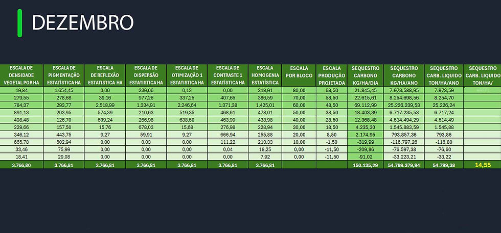
Pigmentation Analysis and Carbon Sequestration
2023 - 2024
2013


2014


2014


2014


2023


Year 2013 (January to December)
TOKEN ID: 878yZhZTiZZsuBCDgTYw5PxRUtawcB4AESMfY7LDDVBb
Name: GREENLINE-ESSS13
Amount: 64,434.85 Credits
Issuance Date: MAY 2024


Year 2014 (January to December)
TOKEN ID: 4JWBKQW2ycePnUXT6gAbYW7VfWtsZuBn8q2XkKBBLSLH
Name: GREENLINE-ESSS14
Amount: 64,758.70 Credits
Issue Date: NOV 2024

